Radiative transfer for
Earth Observation
Rayference is an innovative SME specialising in Earth Observation. Our focus lies in offering extensive technical and scientific expertise in both 1D and 3D radiative transfer modelling. Our flagship products, CISAR - an advanced inversion algorithm - and Eradiate - a cutting-edge open-source 3D Radiative Transfer Model - represent our commitment to excellence in this field.
Portfolio
Eradiate: 3D Radiative transfer model
Eradiate is a flexible, modern, open-source 3D radiative transfer model (RTM) based on the Monte Carlo ray tracing technique designed to represent complex earth scenes. This model aims at providing a flexible framework for activities related with calibration and validation in the Earth observation community. Thanks to its capacity to represent a wide range of different scenes, Eradiate will break boundaries between the Earth observation subcommunities and help them share their scientific advances. We want to make it easy for scientists to improve the accuracy of their numerical simulations by accounting for radiative coupling. For that purpose, Eradiate will ship solvers and optical properties originating from the subcommunities with a common interface. Adding a standard atmosphere profile on top of a detailed forest canopy should not be a painful endeavour, nor should be adding a standard desert surface underneath a complex cloud. Our cover image has been generated using Eradiate to simulate a Savannah scene with a layer of biomass burning aerosols.
Rayference's advanced radiative transfer modelling expertise applies to a series of research projects on diverse fields of research such as vicarious calibration, new mission design and metrology.
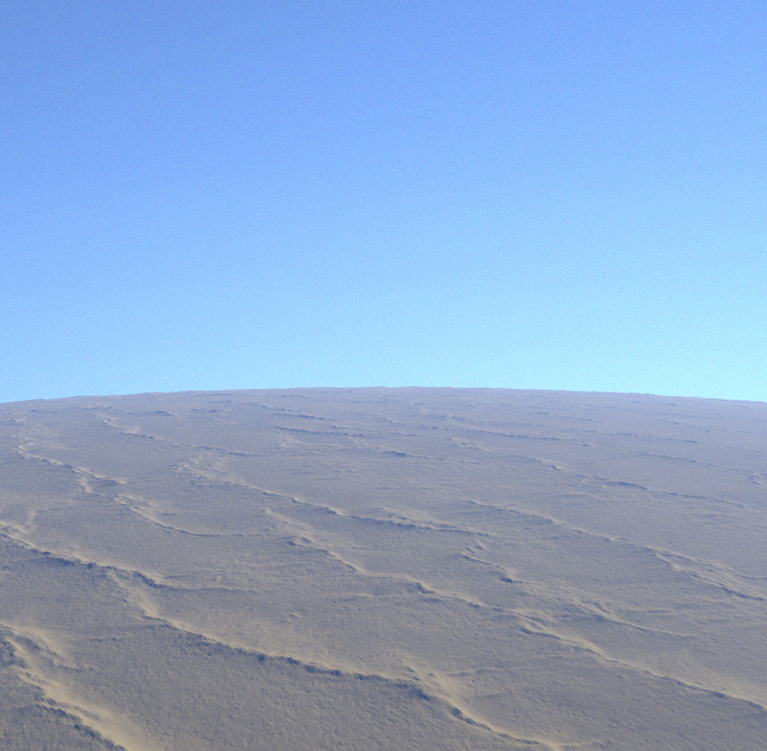
Eradiate allow the simulations of more realistic conditions, accounting for 3D effect and thus improving the accuracy of such simulations. The image on the right shows the simulation of the surface reflectance over Libya-4 accounting for a US standard atmosphere. This simulation is obtained with Eradiate, accounting for the Copernicus DEM at 30m resolution. Eradiate can account for a spherical shell geometry, where both the surface and the atmosphere follow a user-defined planetary radius and the DEM is automatically transformed to follow this curvature.
Eradiate is currently used within the HyperPICS (part of QA4EO framework) and CalibrEO (in collaboration with VITO) projects as well as in the the Metrology for Earth Observation and Climate (MetEOC) series project.
CISAR: Innovative retrieval algorithm
Rayference is specialized in the development of advanced algorithms based on the inversion of radiative transfer models. We have developed the Combined Inversion of Surface and AeRosol (CISAR) algorithm for the retrieval of Essential Climate Variables (ECVs) such as surface reflectance and aerosol/cloud single scattering properties, based on the inversion of a fast 1D RTM model. The optimal estimation inversion provide a strict mathematical framework for uncertainties propagation; retrieval uncertainties are then provided at pixel-level accounting for both input and inversion-related uncertainties. CISAR is a versatile algorithm applicable to any passive sensor acquiring observations in the visible and near infrared region of the solar spectrum with at least one observation every 1-2 days. The latest version of the CISAR algorithm can be applied also to drone measurements to retrieve surface reflectance.
CISAR retrieval of Earth system variables can be exploited in climate studies, atmospheric correction applications and in studies supporting the solar energy industry.
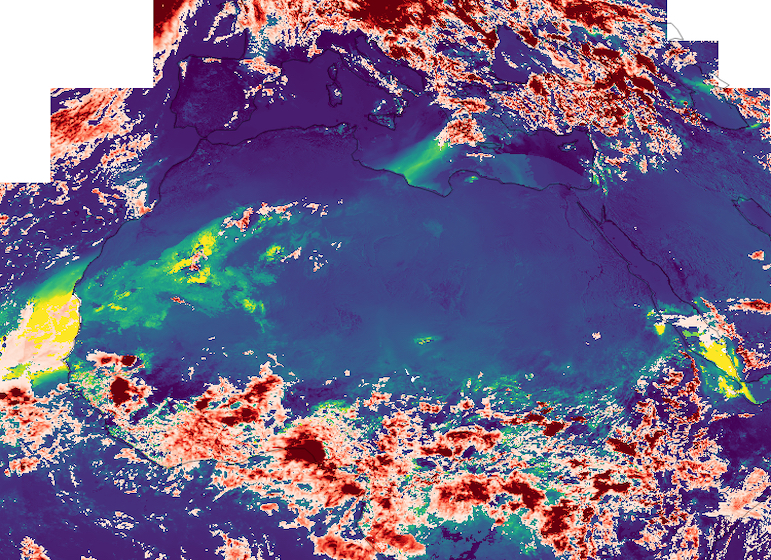
The figure shows an example of combined aerosol/cloud optical thickness retrieval with the CISAR algorithm from SEVIRI data at 10km resolution during the Godzilla dust storm occuring during June 2020. SEVIRI observations are acquired from MSG4 (Zero Degrees mission) and MSG1 (Indian Ocean Coverage Data); combining the two viewing geometry improves the information content, and thus the retrieval performance.
The processing has been performed in the context of the ESA DUST2MSG project.
Currently, CISAR is used within the FDR4VGT ESA project.
Radiometric calibration
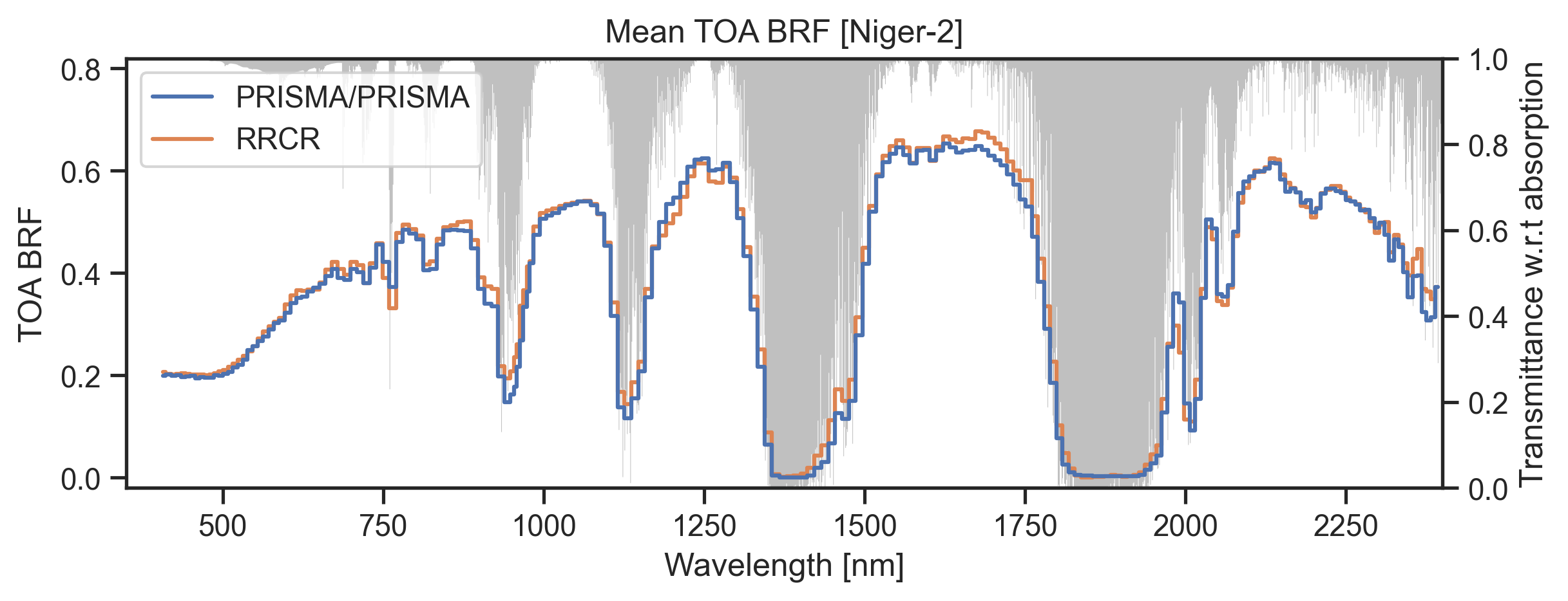
Radiometric calibration is the process of comparing raw observations with a trusted reference, applying an unbroken chain of comparison and uncertainty propagation following metrological principles. Rayference has developed a suite of vicarious calibration methods to support post-launch calibration verification or correction. These methods rely on simulated data with different radiative transfer models over Pseudo Invariant Calibration Sites (PICS) such as deep convective clouds, bright desert and sea surfaces. The current mean accuracy of this method when applied on several tenth of observations acquired in the visible to SWIR spectral regions is about 3%. The Rayference Radiometric Calibration Reference (RRCR) is available in the hyperspectral domain, between 350 and 2500nm over selected PICS. The satellite simulations are obtained using a dataset of surface reflectance retrieved with the (CISAR) algorithm applied to several sensors. The TOA BRF is then simulated with the Eradiate open-source RTM. In order to further improve the accuracy, it is needed to account for 3D effects and polarisation, which likely lead to the larger scattering in the blue region. The image below shows hyperspectral simulations of PRISMA observations over Niger2. The simulations are obtained with the RRCR at 1nm resolution. The shaded grey area represents the atmospheric transmittance. The agreement between the simulations and the observations is remarkable, being well within 3% outside the atmospheric absorption bands. This work has been performed in the context of the EUMETSAT RPV4PICS, in preparation of the launch of Meteosat Third Generation, and ESA Calibreo and HyperPICS projects.
Mean Top-of-atmosphere bidirectional reflectance factor (TOA BRF) mean from PRISMA observations and simulations over Niger2. Wavelength is expressed in nm.
About us
Our mission
We believe in the societal importance of understanding the Earth's climate. This is why we work passionately to provide high quality service on radiative transfer theory applied to the field of environment and climate monitoring as well as supporting green energy, such as solar energy production.
Our team
We are a small team of young physicists and engineers passionate by scientific challenges and ethical principles, developing innovative solutions based on state-of-the-art research to support research and projects aiming at improving our understanding of climate. Do you want to join us? Check out our current job openings!
Our publications
Our clients
|
|
|
|
|---|---|---|
|
|
|
|
|
|
|
|
|
|
|